Property Record
80 Lawrenceville Suwanee Rd, Lawrenceville, GA 30044

NEARBY LISTINGS FOR SALE OR LEASE
Property Detail
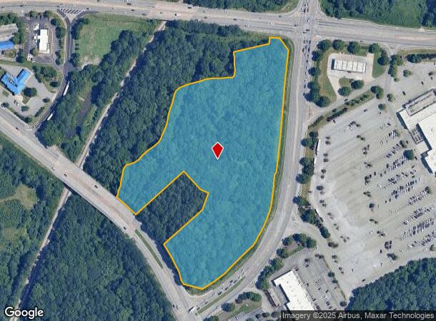
80 Lawrenceville Suwanee Rd
Atlanta-Sandy Springs-Roswell, GA
Suwanee
5-082-195
TR 1 LAWRENCEVILLE SUWANEE ROAD
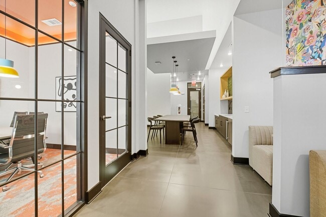
Apartment
Gwinnett
AE
Georgia
13135C0087F
0
0
10.93 AC
2025
Outer Gwinnett County
050589
Atlanta
304,682 SF
DEMOGRAPHICS near 80 Lawrenceville Suwanee Rd
1 mile
3 mile
5 mile
2024 Total Population
10,095
88,254
239,731
2029 Population
10,498
91,660
250,234
Pop Growth 2024-2029
+ 3.99%
+ 3.86%
+ 4.38%
Average Age
37
37
37
2024 Total Households
3,123
29,011
78,363
HH Growth 2024-2029
+ 4.03%
+ 3.95%
+ 4.50%
Median Household Inc
$69,566
$73,682
$73,505
Avg Household Size
3.20
3.00
3.00
2024 Avg HH Vehicles
2.00
2.00
2.00
Median Home Value
$271,137
$278,084
$294,534
Median Year Built
1992
1993
1993
Nearby Places
Map Layers
Map Styles
 Street
 Aerial
Transit
 Traffic
 Biking
Places
Listings with unknown addresses are not visible on the map
- Restaurants
- Banks
- Shops
- Fitness
- Groceries
Nearby Properties
Address
Land Use
TOTAL SIZE
Lot Size
Zoning
Address
Land Use
TOTAL SIZE
Lot Size
Zoning
1,218,930 SF
66.65 AC
OI
Address
Land Use
TOTAL SIZE
Lot Size
Zoning
1,276,197 SF
91.78 AC
OI
Address
Land Use
TOTAL SIZE
Lot Size
Zoning
850,292 SF
70.76 AC
HM
Address
Land Use
TOTAL SIZE
Lot Size
Zoning
275,917 SF
13.34 AC
BG
Address
Land Use
TOTAL SIZE
Lot Size
Zoning
522,601 SF
42.40 AC
RM
Address
Land Use
TOTAL SIZE
Lot Size
Zoning
441,836 SF
35.71 AC
RM13
Address
Land Use
TOTAL SIZE
Lot Size
Zoning
493,520 SF
12.67 AC
BG2
Address
Land Use
TOTAL SIZE
Lot Size
Zoning
486,908 SF
38.98 AC
RM13
Address
Land Use
TOTAL SIZE
Lot Size
Zoning
812,946 SF
82.22 AC
BG2
Address
Land Use
TOTAL SIZE
Lot Size
Zoning
641,171 SF
43.12 AC
RM13
Address
Land Use
TOTAL SIZE
Lot Size
Zoning
303,275 SF
19.80 AC
RM13
Address
Land Use
TOTAL SIZE
Lot Size
Zoning
262,476 SF
20.51 AC
RM13
Address
Land Use
TOTAL SIZE
Lot Size
Zoning
298,990 SF
24.16 AC
RM12
Address
Land Use
TOTAL SIZE
Lot Size
Zoning
333,734 SF
24 AC
BG
Address
Land Use
TOTAL SIZE
Lot Size
Zoning
271,668 SF
20.13 AC
RM13
Address
Land Use
TOTAL SIZE
Lot Size
Zoning
261,174 SF
8.11 AC
MUO
Address
Land Use
TOTAL SIZE
Lot Size
Zoning
279,207 SF
19.14 AC
RM13
Address
Land Use
TOTAL SIZE
Lot Size
Zoning
325,459 SF
21.18 AC
HM
Address
Land Use
TOTAL SIZE
Lot Size
Zoning
206,297 SF
25.06 AC
RA200
Address
Land Use
TOTAL SIZE
Lot Size
Zoning
216,861 SF
21.43 AC
RM13
Address
Land Use
TOTAL SIZE
Lot Size
Zoning
201,000 SF
29.98 AC
R75
Address
Land Use
TOTAL SIZE
Lot Size
Zoning
213,116 SF
15.09 AC
RM12
Address
Land Use
TOTAL SIZE
Lot Size
Zoning
220,161 SF
9.71 AC
OI
Address
Land Use
TOTAL SIZE
Lot Size
Zoning
300,402 SF
24.55 AC
RM13
Address
Land Use
TOTAL SIZE
Lot Size
Zoning
286,368 SF
34.55 AC
R75
Address
Land Use
TOTAL SIZE
Lot Size
Zoning
278,350 SF
35.62 AC
C2
Address
Land Use
TOTAL SIZE
Lot Size
Zoning
357,652 SF
22.03 AC
HM
Address
Land Use
TOTAL SIZE
Lot Size
Zoning
175,190 SF
11.17 AC
RM
Address
Land Use
TOTAL SIZE
Lot Size
Zoning
153,597 SF
13.66 AC
RM13
Address
Land Use
TOTAL SIZE
Lot Size
Zoning
231,373 SF
3.82 AC
OI
The World's #1 Commercial Real Estate Marketplace
Connect with us
© 2026 CoStar Group
The information above has been obtained from sources believed reliable. While we do not doubt its accuracy we have not verified it and make no guarantee, warranty or representation about it. It is your responsibility to independently confirm its accuracy and completeness. Any projections, opinions, assumptions, or estimates used are for example only and do not represent the current or future performance of the property. The value of this transaction to you depends on tax and other factors which should be evaluated by your tax, financial, and legal advisors. You and your advisors should conduct a careful, independent investigation of the property to determine to your satisfaction the suitability of the property for your needs.